Zona do título e menção de responsabilidade
Título próprio
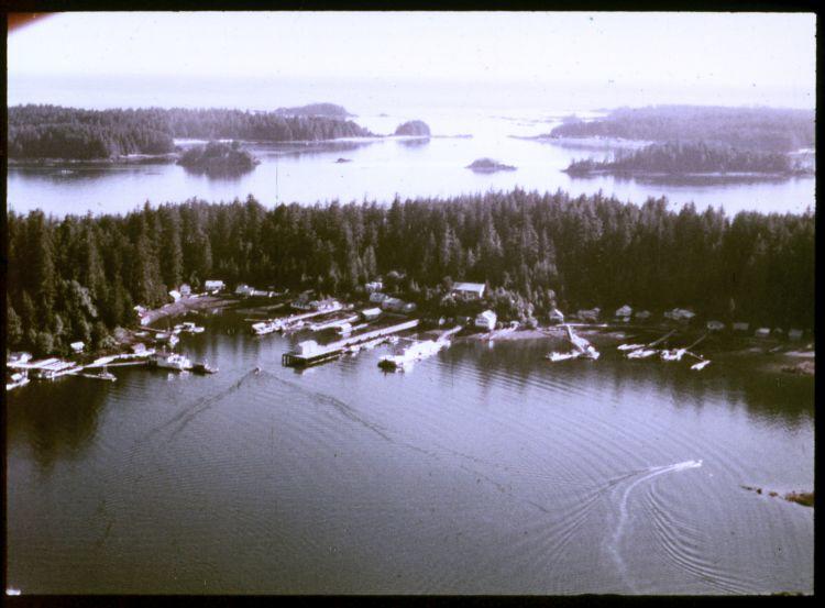
Kyuquot from the air
Designação geral do material
- Graphic material
Título paralelo
Outra informação do título
Título e menções de responsabilidade
Notas ao título
- Source of title proper: Title based on a filmstrip description inventory list included in the collection.
Nível de descrição
Item
Código de referência
Menção de edição
Menção de responsabilidade da edição
Menção da escala (cartográfica)
Menção da projecção (cartográfica)
Menção das coordenadas (cartográfico)
Menção da escala (arquitectura)
Autoridade emissora e denominação (filatélica)
Zona de datas de criação
Data(s)
-
1975 or 1976 (Criação)
Zona de descrição física
Descrição física
1 photograph : 35 mm color negative
Zona dos editores das publicações
Título próprio do recurso continuado
Títulos paralelos das publicações do editor
Outra informação do título das publicações do editor
Menção de responsabilidade relativa ao editor do recurso contínuo
Numeração das publicações do editor
Nota sobre as publicações do editor
Zona da descrição do arquivo
Nome do produtor
História custodial
Âmbito e conteúdo
An image of an aerial view of the Kyuquot village. According to the documentation included with the filmstrip, the description of the image states "Kyuquot from the air. You can see Walter's Island and out into the Pacific Ocean. The next Island to the right is Aktis Island, the ancestral home of the Kyuquot Band. In the early 1800's the Kyuquot Band was the largest on the West Coast of Vancouver Island. However one night in 1855 the Clayoquots, enemies to the Kyoquots, surprised the Kyuquot Village on Atkis Isl., cut off the heads of the Kyuquot warriers, took the women as slaves, and set fire to the village. Most of the village was destroyed during this, the last tribal war fought on the West Coast of Vancouver Island. A few years ago most of the Kyuquot Band left Atkis Island and moved into Walter's Cove."