Title and statement of responsibility area
Titel
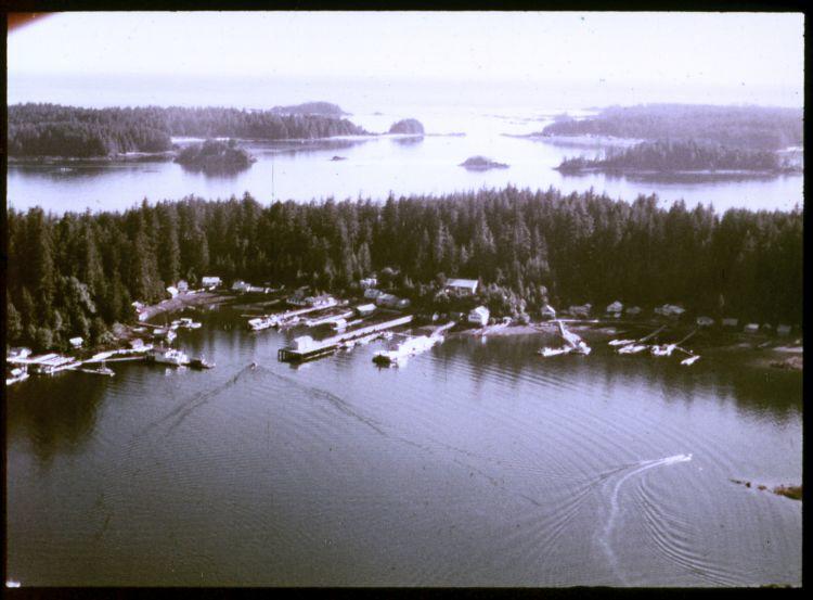
Kyuquot from the air
Algemene aanduiding van het materiaal
- Graphic material
Parallelle titel
Overige titelinformatie
Title statements of responsibility
Titel aantekeningen
- Source of title proper: Title based on a filmstrip description inventory list included in the collection.
Beschrijvingsniveau
Stuk
referentie code
Editie
Edition statement of responsibility
Statement of scale (cartographic)
Statement of projection (cartographic)
Statement of coordinates (cartographic)
Statement of scale (architectural)
Issuing jurisdiction and denomination (philatelic)
Datering archiefvorming
Datum(s)
-
1975 or 1976 (Vervaardig)
Fysieke beschrijving
Fysieke beschrijving
1 photograph : 35 mm color negative
Publisher's series area
Title proper of publisher's series
Parallel titles of publisher's series
Other title information of publisher's series
Statement of responsibility relating to publisher's series
Numbering within publisher's series
Note on publisher's series
Archivistische beschrijving
Naam van de archiefvormer
Geschiedenis beheer
Bereik en inhoud
An image of an aerial view of the Kyuquot village. According to the documentation included with the filmstrip, the description of the image states "Kyuquot from the air. You can see Walter's Island and out into the Pacific Ocean. The next Island to the right is Aktis Island, the ancestral home of the Kyuquot Band. In the early 1800's the Kyuquot Band was the largest on the West Coast of Vancouver Island. However one night in 1855 the Clayoquots, enemies to the Kyoquots, surprised the Kyuquot Village on Atkis Isl., cut off the heads of the Kyuquot warriers, took the women as slaves, and set fire to the village. Most of the village was destroyed during this, the last tribal war fought on the West Coast of Vancouver Island. A few years ago most of the Kyuquot Band left Atkis Island and moved into Walter's Cove."