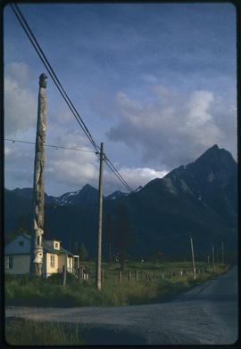
Totem pole in New Hazelton, B.C.
- 134-a040139c
- Stuk
- 26 Aug. 1972
Part of E. Polly Hammer fonds
4096 results with digital objects Show results with digital objects
Totem pole in New Hazelton, B.C.
Part of E. Polly Hammer fonds
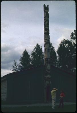
Feast house replica, K-san, B.C.
Part of E. Polly Hammer fonds
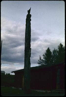
Fiber glass duplicate of very old pole (dog salmon), K-san, B.C.
Part of E. Polly Hammer fonds
Paddling to Where I Stand collection
Collection illustrates the gathering of information and writing of the book “Paddling to Where I Stand : Agnes Alfred, Qwiqwasutinuxw Noblewoman.” Includes interviews to Agnes Alfred conducted by Martine J. Reid and Daisy Sewid-Smith between 1979 and 1985. Interviews are documented as audio and video recordings and their written transcriptions, and other materials gathered by Martine J. Reid and Daisy Sewid-Smith for the edition and publication of the book. Collection also contains the manuscripts and draft for the book; correspondence between Martine J. Reid, Daisy Sewid-Smith and other people; eulogies and funeral pamphlets; Agnes Alfred’s family information; historical notes; and miscellanea. Collection includes photographic materials with photographs included in the book and additional photographs gathered by Martine J. Reid and Daisy Sewid-Smith during their research, and portraits of Agnes Alfred’s parents.
Zonder titel
Part of Minn Sjolseth fonds
File consists of slides labeled "Andy," "Mr and Mrs Williams, Friendly Cove, Nootka," "Anthony Island Queen Charlotte Island 1967," "Minn Sketching at Yan QCI, Haida," "Kitwancool 1969," "Kasper," "Mary Ann 1967 Squamish," and "Kingcome."
Alert Bay, BC 1970 Potlatch Totems
Part of Minn Sjolseth fonds
File consists of slides labeled "Spruceroot digs Emily Minn etc 1967," "Nora pulling spruce roots Tow Hill QCI Aug 1967," and "Alert Bay Sept 1970."
Part of Minn Sjolseth fonds
File consists of slides depicting totems in what the file annotation refers to as Alert Bay and Kingcome.
Part of Lilo Berliner fonds
Includes images of petroglyphs from Kulleet Bay, near Ladysmith BC.
Part of Lilo Berliner fonds
Includes images of petroglyphs from the Monsell Site, on the west bank of the Nanaimo River, near Cedar BC.
Alert Bay Petroglyphs, Quadra Totems
Part of Lilo Berliner fonds
Includes images of petroglyphs, masks and headdresses, and totem poles.
Cape Alava, Mt. Rainier, Cedar-by-the-Sea
Part of Lilo Berliner fonds
Images of petroglyphs, landscapes, plants and animals.
Part of Lilo Berliner fonds
Images of petroglyphs and petroglyph rubbings. One example from the Clo-oos Hill Site
Petroglyphs - Harewood Rubbings
Part of Lilo Berliner fonds
Images of petroglyphs, rubbings, and nature scenes.
Lillooet Petroglyphs, Smithers Fossils
Part of Lilo Berliner fonds
Images of rocks or fossils, masks, a paddlewheeler that houses a library, and a chapel or shed with graves in the background. Images of petroglyphs appear faded.
Petroglyphs Harewood Plains, Prot. Is., Pet Park
Part of Lilo Berliner fonds
Images of petroglyphs.
Kyuquot: Village by the Sea collection
In 1976, a group of students from the Kyuquot Elementary, a First Nations elementary school on the West coast of Vancouver Island, decided to make a filmstrip that documented their lives in the fishing village. The children’s intention behind making these photographs was to raise money for a summer field trip to Victoria, Vancouver, and the Okanagan. As part of the fundraiser, the children made a visual map depicting their daily travel to school by boat and a hand-written order form for the film. Collection consists of documents created by the Kyuquot Elementary School and Mr. Moore, a former Assistant Professor of Anthropology in the 1970s. The collection consists of one correspondence letter written by Mr. Moore requesting a copy of their filmstrip, four pages of typewritten filmstrip descriptions, one handwritten map and flyer created by the Kyuquot Elementary School and one 70 frame color filmstrip that was digitized in 2017. [At the time of processing, it was unknown if the fundraiser was successful.]
Zonder titel
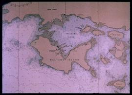
Nautical chart of Walters Island
An image showing a sea map of Walters Island, a small blue circle at the top center indicates the approximate location of the Kyuquot village. According to the documentation included with the filmstrip, the description of the image states "Kyuquot as shown on chart (A chart is a sea-map used by fishermen and boaters.) Compare the chart and the map."
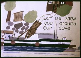
Let Us Show You Around Our Cove
Image of a drawing by the Kyuquot Elementary School children titled "Let us show you around our cove".
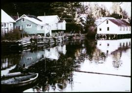
An image showing various houses near the water with people in the distance, the house on the right is built on wooden beams. According to the documentation included with the filmstrip, the description of the image states "The white building on pilings is the store and Post Office. Can you see the last dugout canoe made in Kyuquot?"
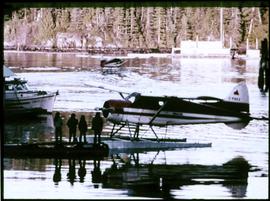
An image showing people standing on a dock next a to a sea plane with a boat nearby. Another plane in taking off in the background. According to the documentation included with the filmstrip, the description of the image states "Waiting for the afternoon scheduled flight of a "Beaver" float plane. Float planes come in twice a day (weather permitting) and bring passengers, freight, and mail."