Mostrando 2792 resultados

Archival description
Wilson Duff fonds
Imprimir vista previa Hierarchy Ver :

1491 resultados con objetos digitales Muestra los resultados con objetos digitales

South Kwakiutl territories

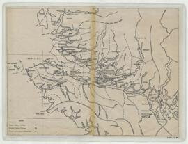
Item is a base map with added notations showing territories of South Kwakiutl tribes; former and present villages; and non-Indian settlements. Includes legend. All typed names of tribes and villages have been crossed through with pencil.
Item appears to be a working copy or preliminary draft of item #40. Sheets originally taped together.
Encapsulated. Base map: Southern Kwakiutl base map, Duff-CM-14.

Lowe Inlet and Portland Inlet

Item consists of detail map of Lowe Inlet, located on the peninsula between Chatham Sound and Douglas Channel, and map of Portland Inlet area, from Port Simpson to Greenville. Notation "Edward Gamble (Tsibasa) 1939." In English and Tsimshian. Detail of areas shown in Duff-CM-69.

Images: Stone B.C. records

Correspondence, news clippings, installation and exhibition photographs, and press kits from the Images: Stone: B.C. exhibit that was displayed at the Vancouver Art Gallery and the Greater Victoria Art Gallery. Also includes 2 cassette tapes from the Vancouver Art Gallery dated May 6, 1975 and 1 U-Matic videocassette titled “Images: Stone B.C.: Hilary Stewart, Wilson Duff” dated May 16, 1975.

Resultados 2581 a 2600 de 2792